

Barreirinhas
How would you like to explore this place?
Read the guidePlan your stayExplore the villagePlaces, services and conditionsGetting thereCheck conditionsView on the mapFind a place. Choose your next step.
Select a village to find its guides and next steps.
How would you like to explore this place?
Read the guidePlan your stayExplore the villagePlaces, services and conditionsGetting thereCheck conditionsView on the mapHow would you like to explore this place?
Read the guidePlan your stayExplore the villagePlaces, services and conditionsGetting thereCheck conditionsView on the mapHow would you like to explore this place?
Read the guidePlan your stayExplore the villagePlaces, services and conditionsGetting thereCheck conditionsView on the mapHow would you like to explore this place?
Read the guidePlan your stayExplore the villagePlaces, services and conditionsGetting thereCheck conditionsView on the mapHow would you like to explore this place?
Read the guidePlan your stayExplore the villagePlaces, services and conditionsGetting thereCheck conditionsView on the mapHow would you like to explore this place?
Read the guidePlan your stayExplore the villagePlaces, services and conditionsGetting thereCheck conditionsView on the mapHow would you like to explore this place?
Read the guidePlan your stayExplore the villagePlaces, services and conditionsGetting thereCheck conditionsView on the mapHow would you like to explore this place?
Read the guidePlan your stayExplore the villagePlaces, services and conditionsGetting thereCheck conditionsView on the mapHow would you like to explore this place?
Read the guidePlan your stayExplore the villagePlaces, services and conditionsGetting thereCheck conditionsView on the mapHow would you like to explore this place?
Read the guidePlan your stayExplore the villagePlaces, services and conditionsGetting thereCheck conditionsView on the mapHow would you like to explore this place?
Read the guidePlan your stayExplore the villagePlaces, services and conditionsGetting thereCheck conditionsView on the mapHow would you like to explore this place?
Read the guidePlan your stayExplore the villagePlaces, services and conditionsGetting thereCheck conditionsView on the mapHow would you like to explore this place?
Read the guidePlan your stayExplore the villagePlaces, services and conditionsGetting thereCheck conditionsView on the mapHow would you like to explore this place?
Read the guidePlan your stayExplore the villagePlaces, services and conditionsGetting thereCheck conditionsView on the mapHow would you like to explore this place?
Read the guidePlan your stayExplore the villagePlaces, services and conditionsGetting thereCheck conditionsView on the mapHow would you like to explore this place?
Read the guidePlan your stayExplore the villagePlaces, services and conditionsGetting thereCheck conditionsView on the mapHow would you like to explore this place?
Read the guidePlan your stayExplore the villagePlaces, services and conditionsGetting thereCheck conditionsView on the mapHow would you like to explore this place?
Read the guidePlan your stayExplore the villagePlaces, services and conditionsGetting thereCheck conditionsView on the mapHow would you like to explore this place?
Read the guidePlan your stayExplore the villagePlaces, services and conditionsGetting thereCheck conditionsView on the mapHow would you like to explore this place?
Read the guidePlan your stayExplore the villagePlaces, services and conditionsGetting thereCheck conditionsView on the mapHow would you like to explore this place?
Read the guidePlan your stayExplore the villagePlaces, services and conditionsGetting thereCheck conditionsView on the mapHow would you like to explore this place?
Read the guidePlan your stayExplore the villagePlaces, services and conditionsGetting thereCheck conditionsView on the mapHow would you like to explore this place?
Read the guidePlan your stayExplore the villagePlaces, services and conditionsGetting thereCheck conditionsView on the mapHow would you like to explore this place?
Read the guidePlan your stayExplore the villagePlaces, services and conditionsGetting thereCheck conditionsView on the mapHow would you like to explore this place?
Read the guidePlan your stayExplore the villagePlaces, services and conditionsGetting thereCheck conditionsView on the mapHow would you like to explore this place?
Read the guidePlan your stayExplore the villagePlaces, services and conditionsGetting thereCheck conditionsView on the mapHow would you like to explore this place?
Read the guidePlan your stayExplore the villagePlaces, services and conditionsGetting thereCheck conditionsView on the mapHow would you like to explore this place?
Read the guidePlan your stayExplore the villagePlaces, services and conditionsGetting thereCheck conditionsView on the mapOne decision at a time, from itinerary to packing.
MARANHÃO · PIAUÍ · CEARÁ
From the Lençóis to Jeri, find the stops and see what changes along the way.
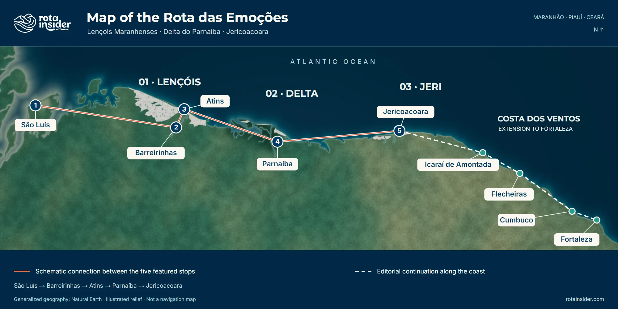
An artistic interpretation of the terrain. The base map is still there as you zoom in.
The base map didn't fully load. The stops and the details are still available.
UNDERSTANDING THE PLACE COMES FIRST
The Lençóis are dunes and lagoons. In the Delta, the channels run between islands and mangroves. In Jeri, the Serrote meets the coast. After that, the journey can carry on through Icaraí, Flecheiras and Cumbuco to Fortaleza.
THE GEOGRAPHY OF THE JOURNEY
The Rota das Emoções connects the Lençóis Maranhenses, the Delta do Parnaíba and Jericoacoara, along the coast of Maranhão, Piauí and Ceará. On this map, five stops help you follow the route from west to east: São Luís, Barreirinhas, Atins, Parnaíba and Jericoacoara. That's just a way to get your bearings, not a set order to travel in.
MARANHÃO
In Maranhão, dunes and lagoons form the landscape of the Lençóis Maranhenses. Barreirinhas sits on the Rio Preguiças; Atins is on the coast, close to its mouth. Santo Amaro offers another reference point west of the dune field.
MARANHÃO / PIAUÍ
Between Maranhão and Piauí, the Rio Parnaíba splits into channels among islands and mangroves. Tutóia helps you locate the Maranhão side; Parnaíba, the Piauí side. Barra Grande lies farther along the Piauí shore — not on an island in the Delta.
CEARÁ
In Ceará, Jericoacoara brings together dunes, coast and the rocky Serrote. Camocim lies to the west; Preá, east of the village of Jeri. They sit close together in this regional reading, each with its own character and its own way in.
FROM ICARAÍ TO FORTALEZA · EXTENSION
After Jeri, this reading of the map extends through Icaraí de Amontada, Flecheiras and Cumbuco to Fortaleza. “Costa dos Ventos” is the name of this editorial chapter; the extension appears separately from the three central landscapes.
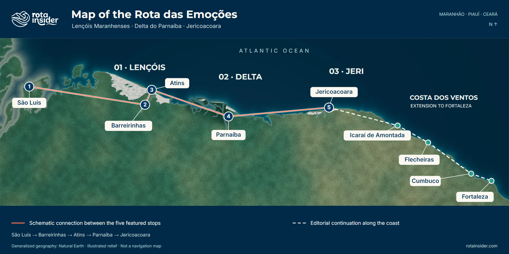
THE ROUTE IN ONE IMAGE
The regions and the main stops are identified in this illustrated version too. Open the image to enlarge it, or save it for later.
Download the illustrated mapTo choose how to travel, use Rota Genius. This drawing is not a substitute for a navigation map.
“Costa dos Ventos” is the name used here for the editorial continuation to Fortaleza. The exploration outlines are not official ecosystem or park boundaries. The lines connect places schematically; they are not navigation tracks. Satellite imagery does not show real-time conditions. The illustrated relief is artwork, not an elevation survey.
The five main stops between São Luís and Jericoacoara — each village with its ecosystem, access and nearby villages.
Lençóis Maranhenses
Azulejos, reggae and the old lighthouse — the gateway to the wild coast.
Access: Paved road
Lençóis Maranhenses
The dune base — where 4×4s set out for the Lençóis and the Preguiças river drifts to the sea.
Access: Paved road
Nearby villages
Lençóis Maranhenses
Where the Preguiças meets the Atlantic — kite, living dunes, the northern edge of the Lençóis.
Access: Sand (4×4)
Parnaíba Delta
The delta, the scarlet ibises, and the wildest sunset in Brazil.
Access: Paved road
Nearby villages
Jericoacoara
The sunset dune, the wind, and the sand that never ends.
Access: Sand (4×4)
Before you go — what's worth knowing.
Across the 6–10 day window, per person — three comfort tiers.
R$ 400–640 for intercity transport alone. Lodging doubles in high season (Jan–Feb).
Full lagoons and steady wind: June to September.
July is the peak — lagoons at their fullest. Mar–Apr: heavy rain, lagoons still filling.
Recommended: 6–10 days — from the classic pace to an unhurried ideal.
March and April are the trickiest months: it rains hard, sand roads get difficult and some river crossings are suspended. The Lençóis lagoons are still filling — waiting until May doubles the water level. If your window is locked into this period, prioritize Atins (dry-season lodging) and Jeri (the wind starts to firm up in April).
It's doable, but with adjustments. It's domestic-tourism high season, prices rise 30–60% and the guesthouses fill up. The Lençóis lagoons are at their highest in February–March. Book everything 60 days ahead and favor Tuesday to Thursday for transfers — weekends get overloaded on the São Luís → Barreirinhas leg.
Yes, and it's common for travelers already in Ceará. Same legs, same prices, same tide dependencies. The one practical difference: arranging the trip out of Jericoacoara to Parnaíba is easier from Jeri than the other way around — look for guesthouses that organize a direct transfer. Entering Atins from the Delta is where the tide timing matters most.
For the Atins → Delta → Jericoacoara leg, a guide or agency is recommended — the transport is informal and depends on the tide. The São Luís → Barreirinhas leg is easy to do on your own. With Rota Insider, you get transport quotes directly from local operators.
No. Almost no one does the route in their own 4x4 — it's cheaper and easier to hire local transfers (vans, open-top trucks, speedboats) at each point. Inside the parks (Lençóis, Jeri), only accredited operators can drive through anyway. If you want freedom of movement, rent a buggy or 4x4 at specific destinations, not for the whole route.
São Luís → Barreirinhas: van or bus (4h, paved). Barreirinhas → Atins: speedboat on the Preguiças river (~1h, scheduled line boats). Atins → Parnaíba: 4×4 along the beach + van (5–6h; the beach stretch depends on low tide). Parnaíba → Jericoacoara: van or bus (4h, paved + sand).
Yes, on the beach stretch. There is no direct boat from Atins to Parnaíba: the leg runs by 4×4 along the beach, which is only passable at low tide, and then by van on the road to Parnaíba — 5 to 6 hours in all. The operator sets the departure time the day before, from that day's tide table.
SLZ airport (Marechal Cunha Machado). Direct flights from GRU (São Paulo), GIG/SDU (Rio) and BSB (Brasília) — about 3h30. Many flights connect through FOR (Fortaleza) or REC (Recife) at lower fares. To leave Jericoacoara at the end of the route, the nearest airport is JJD (Jericoacoara/Cruz), with flights to FOR, GRU and BSB; an alternative is to take a 4h transfer to FOR and fly from there.
These are villages of 500 to 3,000 people where everyone knows everyone. Most tourist movement is with local operators you book through your guesthouse. Atins and Jericoacoara have a strong solo-traveler presence, women included — the network of guesthouses + local operators makes the route one of the most accessible in the Northeast for solo travel. Normal travel precautions apply: avoid moving around with valuables on show, and favor transport recommended by your guesthouse.
Get a quote from a local operator, take the route offline in the app, or read the full guide.
Talk directly with a local operator about the leg you need — van, speedboat, or 4×4 + van. Reply in minutes.
Offline tide tables for the beach stretch and the Delta, saved routes and maps with no signal.
An in-depth day-by-day guide, with side stops, costs per leg and tips on places to stay.
Read the full Route of Emotions itineraryKeep exploring